Datei:Mainzer Adelsverein Karte von Indian Point od. Indianola 1851 UTA.jpg
Originaldatei (2.671 × 1.574 Pixel, Dateigröße: 4,01 MB, MIME-Typ: image/jpeg)
![]()
Diese Datei und die Informationen unter dem roten Trennstrich werden aus dem zentralen Medienarchiv Wikimedia Commons eingebunden.
![]()
Beschreibung
| Titel |
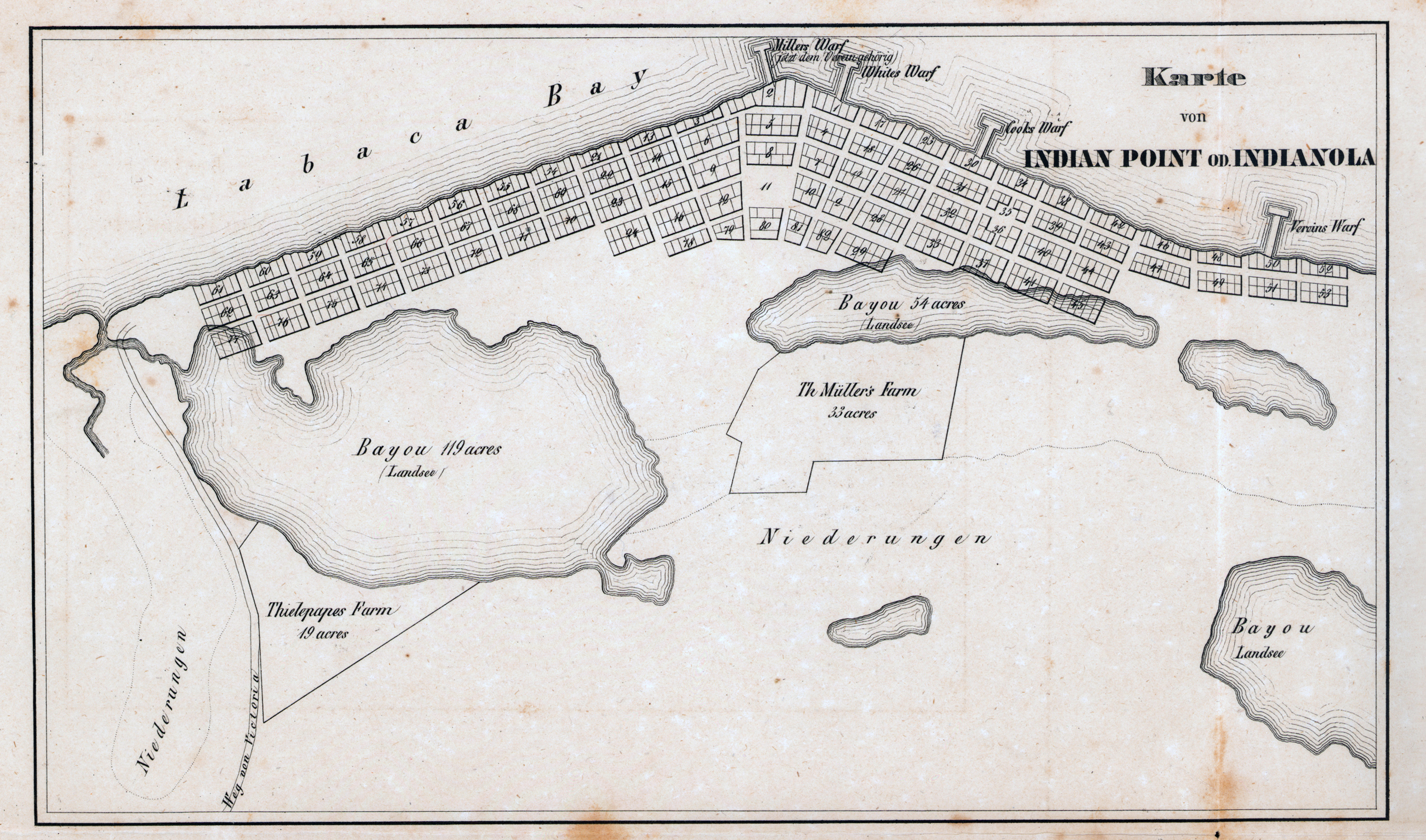
Deutsch: Karte von Indian Point od. Indianola |
||||||||||||||||||||||||||
| Beschreibung |
English: This town plan was part of a packet of materials published in 1851 by the Verein zum Schutze Deutscher Auswanderer nach Texas (Society for the Protection of German Emigrants to Texas, also known as the Adelsverein or Society of Nobles headquartered in Mainz and Wiesbaden). The port town and harbor of Indianola and the towns of New Braunfels and Fredericksburg all figured prominently in this project to settle hundreds of German emigrants in Texas during the 1840s and early 1850s. Employees of the Adelsverein who probably prepared these maps included Hermann Willke (ca.1822-after 1865), a young surveyor-engineer and Prussian army veteran and possibly Nicolaus Zink (1812-1887), also a surveyor-engineer and Bavarian army veteran who laid out the colony's town of New Braunfels. |
||||||||||||||||||||||||||
| Datum | 1850–1851 | ||||||||||||||||||||||||||
| Quelle | UTA Libraries Cartographic Connections: Karte / Text | ||||||||||||||||||||||||||
| Urheber | |||||||||||||||||||||||||||
| Anerkennung |
English: The University of Texas at Arlington Libraries Special Collections |
||||||||||||||||||||||||||
| Kartografische Angaben | |||||||||||||||||||||||||||
| Ortsbezug | Indianola (Texas) | ||||||||||||||||||||||||||
| Georeferenzierung | If inappropriate please set warp_status = skip to hide. | ||||||||||||||||||||||||||
| Bibliographische Angaben | |||||||||||||||||||||||||||
| Erscheinungsort | Wiesbaden | ||||||||||||||||||||||||||
| Verleger |
Verein zum Schutze Deutscher Auswanderer nach Texas |
||||||||||||||||||||||||||
| Drucker |
H. Delius, Berlin |
||||||||||||||||||||||||||
| Archivalische Angaben | |||||||||||||||||||||||||||
| Sammlung |
|
||||||||||||||||||||||||||
| Maße | Höhe: 27 cm; Breite: 39 cm | ||||||||||||||||||||||||||
| Technik | Lithografie auf Papier | ||||||||||||||||||||||||||
| artwork-references |
Huseman, Ben W. (2010) Charting Chartered Companies: Concessions to Companies as Mirrored in Maps, 1600-1900, Arlington: The University of Texas at Arlington Library, Nr. 40, 41 , S. 32–34 Crystal Sasse Ragsdale (June 15, 2010). Zink, Nicolaus. Handbook of Texas Online. Texas State Historical Association. Retrieved on July 25, 2019. Biesele, Rudolph Leopold (1930) The History of the German Settlements in Texas 1831-1861, Austin: Von Boeckmann-Jones Co. |
||||||||||||||||||||||||||
| Andere Versionen | |||||||||||||||||||||||||||

Lizenz

|
This file was provided to Wikimedia Commons by the University of Texas at Arlington Libraries as part of a cooperation project. The University of Texas at Arlington Libraries is part of the University of Texas at Arlington, a public research university located in Arlington, Texas.
|
|
Der Urheber dieses Werks ist 1887 gestorben; es ist daher gemeinfrei, weil seine urheberrechtliche Schutzfrist abgelaufen ist. Dieses Werk ist gemeinfrei in den Vereinigten Staaten, weil es vor dem 1. Januar 1929 veröffentlicht (oder beim U.S. Copyright Office registriert) wurde. | |
| Es wurde festgestellt, dass diese Datei frei von bekannten Beschränkungen durch das Urheberrecht ist, alle verbundenen und verwandten Rechte eingeschlossen. | |
Dateiversionen
Klicke auf einen Zeitpunkt, um diese Version zu laden.
| Version vom | Vorschaubild | Maße | Benutzer | Kommentar | |
|---|---|---|---|---|---|
| aktuell | 23:58, 26. Jul. 2019 | | 2.671 × 1.574 (4,01 MB) | Michael Barera | == {{int:filedesc}} == {{Map |title = ''Karte von Indian Point od. Indianola'' |description = {{en|This town plan was part of a packet of materials published in 1851 by the ''Verein zum Schutze Deutscher Auswanderer nach Texas'' (Society for the Protection of German Emigrants to Texas, also known as the Adelsverein or Society of Nobles headquartered in Mainz and Wiesbaden). The port town and harbor of Indianola and the towns of New Braunfels and Fredericksburg all figured... |
Dateiverwendung
Die folgenden 2 Seiten verwenden diese Datei: