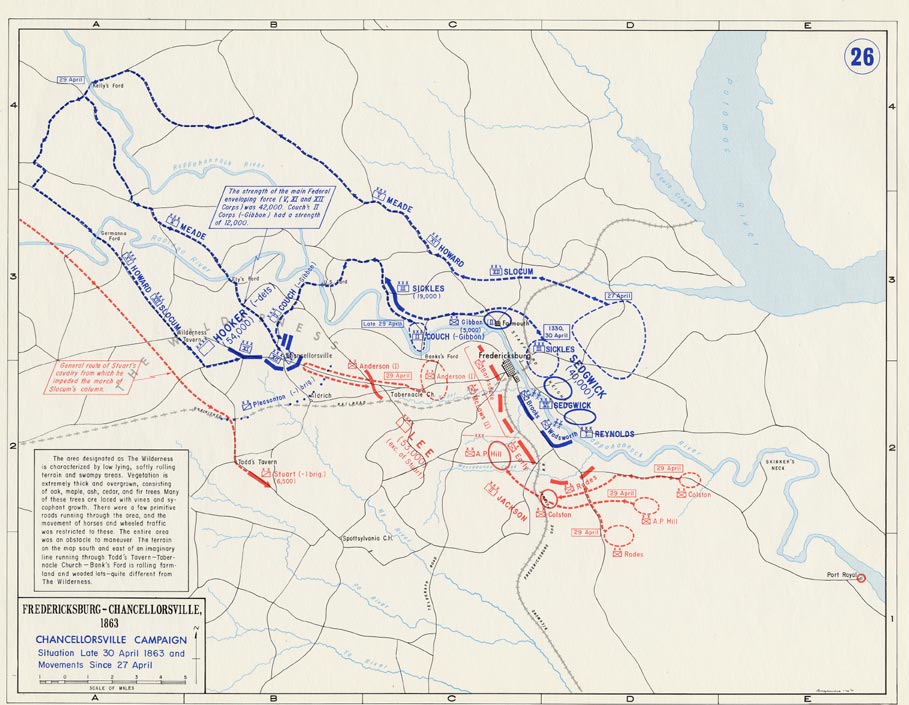
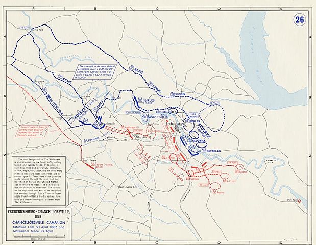
Datei:Situation Late 30. April 1863 and Movements since 27 April.jpg
Originaldatei (909 × 705 Pixel, Dateigröße: 116 KB, MIME-Typ: image/jpeg)
![]()
Diese Datei und die Informationen unter dem roten Trennstrich werden aus dem zentralen Medienarchiv Wikimedia Commons eingebunden.
![]()
Beschreibung
- Description: Battle of Chancellorsville, Situation Late 30. April 1863 and Movements since 27. April
- Source: www.dean.usma.edu
- Background information:
In 1938 the predecessors of what is today The Department of History at the United States Military Academy began developing a series of campaign atlases to aid in teaching cadets a course entitled, "History of the Military Art." Since then, the Department has produced over six atlases and more than one thousand maps, encompassing not only America’s wars but global conflicts as well.
In keeping abreast with today's technology, the Department of History is providing these maps on the internet as part of the department's outreach program. The maps were created by the United States Military Academy’s Department of History and are the digital versions from the atlases printed by the United States Defense Printing Agency. We gratefully acknowledge the accomplishments of the department's former cartographer, Mr. Edward J. Krasnoborski, along with the works of our present cartographer, Mr. Frank Martini.
Please be aware that these maps are large in file size and may require substantial download times.
Lizenz
Dieses Bild wurde von einem Mitglied der United States Army während der Ausführung seiner Dienstpflichten erstellt. Als eine Arbeit der Bundesregierung der Vereinigten Staaten ist dieses Bild in public domain.
|
 |
Dateiversionen
Klicke auf einen Zeitpunkt, um diese Version zu laden.
| Version vom | Vorschaubild | Maße | Benutzer | Kommentar | |
|---|---|---|---|---|---|
| aktuell | 18:22, 5. Mai 2016 | | 909 × 705 (116 KB) | FDRMRZUSA | Reverted to version as of 19:09, 24 February 2006 (UTC) |
| 18:21, 5. Mai 2016 |  | 3.200 × 2.450 (5,9 MB) | FDRMRZUSA | Reverted to version as of 16:10, 5 May 2016 (UTC) | |
| 18:18, 5. Mai 2016 |  | 909 × 705 (116 KB) | FDRMRZUSA | Reverted to version as of 19:09, 24 February 2006 (UTC) | |
| 18:10, 5. Mai 2016 |  | 3.200 × 2.450 (5,9 MB) | FDRMRZUSA | New map size and design. Same license. | |
| 21:09, 24. Feb. 2006 |  | 909 × 705 (116 KB) | Edmund Ferman | == Summary == *Description: '''''Federal Advance, Battle of Cold Harbor, Movement to James River and Siege of Petersburg''''' *Source: [http://www.dean.usma.edu/history/web03/atlases/american%20civil%20war/acw%20pages/acw47.html www.dean.usma.edu] *Back |
Dateiverwendung
Die folgende Seite verwendet diese Datei:
Globale Dateiverwendung
Die nachfolgenden anderen Wikis verwenden diese Datei:
- Verwendung auf no.wikipedia.org