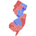
Datei:2021 New Jersey gubernatorial election results map by county.svg
Zur Navigation springen
Zur Suche springen

Größe der PNG-Vorschau dieser SVG-Datei: 600 × 600 Pixel. Weitere aus SVG automatisch erzeugte PNG-Grafiken in verschiedenen Auflösungen: 240 × 240 Pixel | 480 × 480 Pixel | 768 × 768 Pixel | 1.024 × 1.024 Pixel | 2.048 × 2.048 Pixel | 810 × 810 Pixel
Originaldatei (SVG-Datei, Basisgröße: 810 × 810 Pixel, Dateigröße: 31 KB)
Dateiversionen
Klicke auf einen Zeitpunkt, um diese Version zu laden.
| Version vom | Vorschaubild | Maße | Benutzer | Kommentar | |
|---|---|---|---|---|---|
| aktuell | 05:45, 23. Jun. 2023 |  | 810 × 810 (31 KB) | Putitonamap98 | shapes |
| 05:29, 21. Nov. 2022 |  | 744 × 744 (126 KB) | Putitonamap98 | Reverted to version as of 00:08, 4 November 2021 (UTC) these are the standard shapes check description | |
| 04:20, 4. Nov. 2021 |  | 744 × 744 (131 KB) | Fluffy89502 | better map | |
| 02:08, 4. Nov. 2021 |  | 744 × 744 (126 KB) | Twotwofourtysix | Updates Hunterdon, Mercer, and Monmouth counties | |
| 17:17, 3. Nov. 2021 |  | 744 × 744 (125 KB) | Elli | update | |
| 07:56, 3. Nov. 2021 |  | 744 × 744 (125 KB) | Elli | update | |
| 07:51, 3. Nov. 2021 |  | 744 × 744 (125 KB) | Elli | update | |
| 07:48, 3. Nov. 2021 |  | 744 × 744 (125 KB) | Elli | update | |
| 07:46, 3. Nov. 2021 |  | 744 × 744 (125 KB) | Elli | update | |
| 06:18, 3. Nov. 2021 |  | 744 × 744 (125 KB) | Elli | update |
Dateiverwendung
Die folgenden 3 Seiten verwenden diese Datei:
Globale Dateiverwendung
Die nachfolgenden anderen Wikis verwenden diese Datei:
- Verwendung auf en.wikipedia.org
- Verwendung auf es.wikipedia.org
- Verwendung auf fr.wikipedia.org
- Verwendung auf ko.wikipedia.org
- Verwendung auf simple.wikipedia.org
